FEMA Tool Provides Comprehensive View of Hazard Risk (FEMA) The Resilience Analysis and Planning Tool (RAPT) was released earlier this year to help identify areas for building resilience, response, and recovery capabilities. Developed by FEMA and Argonne National Laboratory, RAPT is a geographic information system (GIS) webmap tool with clickable layers of community resilience indicators, infrastructure locations, and hazard data, and widgets to help with analysis. RAPT includes GIS layers of historic hazard data for tornados, tropical storms, and wildfire; risk assessments for seismic and flooding events; and real-time watch and warning notifications from the National Weather Service. Jurisdictions can click on multiple hazard layers at a time to see a more comprehensive view of hazard risk.
Severe Repetitive Flooding, Flood Data Visualization Tool (Natural Resources Defense Council) The federal government’s efforts to reduce repeated flooding are not keeping pace with current risk—let alone the increasing risk posed by sea level rise, increased severe weather, and other climate change impacts. This data dashboard illustrates the number of Severe Repetitive Loss Properties in each state and county, along with National Flood Insurance Program claims. Use the drop-down menus at the top of the map to filter by location, and check the graphs to view trends in repeatedly flooded properties.
FEMA Adjusts Consumer Price Index for 2021 (FEMA) FEMA has provided financial guidance for all disasters declared on or after Oct. 1, 2020. This guidance reflects the 2021 Consumer Price Index adjustment of certain indicators for the Individual Assistance and Public Assistance programs. The index adjusted annually for inflation by the U.S. Department of Labor—has increased 1.3% for Fiscal Year 2021. Therefore, the following FEMA program amounts have been changed and will remain in effect for the next 12 months.
New ‘Mitigate Your Risk’ feature on FEMA app (FEMA) New content is available on the FEMA app, which lists the types of disasters common for an area and provides do-it-yourself mitigation tips. The tips are low-cost or no-cost and help prevent future losses after a disaster. Users can enter a zip code or city name to view a list of common disasters in the area and get tips on how to prepare. The app also allows the user to sign up to receive severe weather, environmental and other public hazard alerts for up to five locations of interest. The FEMA app has been downloaded more than one million times on Google Play and is ranked 14 in the Weather category of the App Store. Using a mobile device, download the FEMA app for free from the App Store and Google Play
CMAT Program Offers Community Wildfire Mitigation Assistance (U.S. Forest Service) The nation is in the midst of another horrendous wildfire season. Communities are under siege. It’s too late to offer mitigation assistance for some communities but for many this is a chance to establish or strengthen local mitigation programs. The National Community Mitigation Assistance Team (CMAT), supported by the U.S. Forest Service and the National Association of State Foresters, may be able to help.CMATs help support and position communities to do wildfire mitigation work themselves through effective, sustainable partnerships using the right methods and tools.
Articles
All-Hazards:
FEMA to Fly 642 Shelter Pets to Safety on Historic Rescue Flight (GreaterGood)
Search & Rescue: Rapid Rescue of Buried People (HS Newswire)
New Simulation Technology Helps Get the Jump on Wildfires (EM / Gov Tech)
Beyond 9/11: U.S. Security Needs in the 21st Century (HS Newswire) and Homeland Threat Assessment, October 2020 (HS Digital Library)
5 of California’s 6 Largest Fires on Record Are Burning Now: The Astonishing 2020 Wildfire Season in Context (Union of Concerned Scientists)
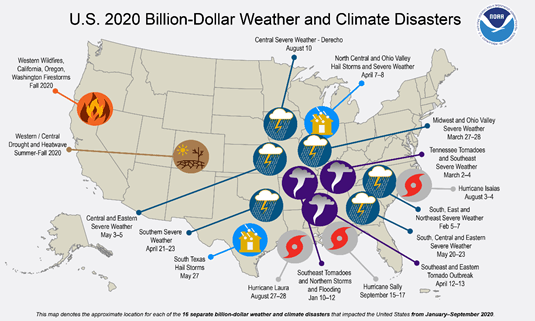
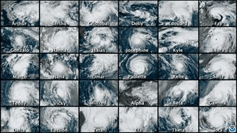
U.S. Hit By 16 Billion-Dollar Disasters This Year, So Far (NOAA)
Resilience:
Florida Braces for a Storm of Homeowners Insurance Rate Hikes (Bloomberg)
Hospital Resilience-Operational Perspectives from COVID-19 (Dom. Prep)
The unlikely birthplace of the most destructive hurricanes(BBC)
Public Health / Biosurveillance:
When Disasters Strike, Nursing Homes Residents Face Considerable Risk (Medical Xpress)
State of the Nation: A 50-State COVID-19 Survey: Report #14: Misinformation and Vaccine Acceptance (HS Digital Library)
Bringing Calm to Chaos: The Hospital Incident Command System (HICS) & the Coronavirus Pandemic (Dom. Prep)
U.S. COVID Deaths May Be Underestimated by 36 Percent (HS Newswire)
Critical Infrastructure & Cyber:
Strengthening the Cyber Resilience of North American Energy Systems (HS Digital Library)
Alabama’s Power Grid Reimage After Hurricane Sally Includes Solar (EM / Gov Tech)
Geolocation Data Could Help Planners Design Communities that Require Less Driving (Route Fifty)
Innovations & Interconnections:
Essential Role of Satellites in Disaster and Pandemic Management (ROOM)
How Coronavirus Is Changing Claims, Risks, Work, Habits, Supply Chains and More (Ins Journal) and COVID-19 Business Adjustments Are Changing Fire Safety (EDM Digest)
Can You Pay Your Deductible? Survey Says 78% Can’t Afford to File an Insurance Claim (Bankrate)
Insider a Tech-Driven Rebuilding Shop for Wildfire Victims (LA Times)
